ID:222 The 2011 Great East Japan Earthquake and Tsunami —the Past and the Future—
- Date
- 2015.3.14-18
- Venue
- Tohoku University Kawauchi-kita Campus A102
- Time
- 10:00-20:00
Inquiry
E-mail:murao*irides.tohoku.ac.jp (Please replace * to @)
Organization
Tohoku University International Research Institute of Disaster Science (IRIDeS)
Tags


Report
| Number of participants | 100 |
|---|
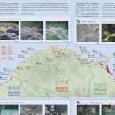
The 2011 Great East Japan Earthquake and Tsunami affected not only seriously damaged Iwate, Miyagi, and Fukushima prefectures but also Aomori, Ibaraki, and Chiba prefectures. The total inundated areas by the tsunami covered about 561km2 in the six prefectures (Geospatial Information Authority of Japan, 2011). Each municipality devised post-tsunami recovery plans for the damaged areas in 2011 or 2012 according to its damage situation and regional context.
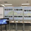
We exhibited the map showing coastline of the six affected prefectures from Aomori in the north to Chiba in the south, consisting of seventy municipalities, illustrated the inundated areas by the tsunami that help us understand differences of regional characteristics. In addition, the illustration contained data of inundated areas and some basic information on recovery situation for each prefecture, the number of temporary houses constructed as of April 2013, and the number of tsunami evacuation buildings and towers as of March 2011 and August 2013.
We presented the geographical changes visibly by a slide show as well, regarding the data before and after the disaster of ten coastal areas in Miyagi and Fukushima prefecture.